In December 1972, astronauts aboard NASA’s Apollo 17 mission snapped a photograph that would change how we see our planet forever. Known as the “Blue Marble,” it was the first image to capture the entire Earth in full sunlight, a breathtaking view of a radiant blue globe suspended in the void of space. I remember the first time I saw that image in a science textbook as a kid—it was mesmerizing, like a cosmic reminder of how small yet precious our world is. Fast forward 50 years, and new images from NASA’s Deep Space Climate Observatory (DSCOVR) reveal a planet that looks strikingly different. Climate change, driven by human activity, has left visible scars on the Blue Marble, transforming its icy poles, sprawling deserts, and lush forests. This article explores how five decades of environmental shifts have reshaped Earth’s appearance from space, why it matters, and what we can do about it.
The Blue Marble: A Symbol of Fragility
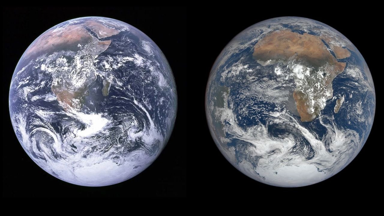
The original Blue Marble, taken on December 7, 1972, by astronaut Harrison Schmitt using a Hasselblad camera, showed Earth glowing against the blackness of space. From 29,400 kilometers away, it captured the African continent, the Arabian Peninsula, and the Antarctic ice cap, with swirling clouds and vibrant oceans. It wasn’t just a photo—it sparked the environmental movement, inspiring a sense of awe and responsibility. The image became a symbol of Earth’s fragility, a reminder that we live on a finite, interconnected planet.
A Snapshot That Changed Perspectives
The Blue Marble’s impact was profound. It appeared on postage stamps, book covers, and even in Al Gore’s An Inconvenient Truth. Astronauts like Scott Kelly have described the “overview effect”—a humbling sense of unity and environmental awareness from seeing Earth from space. For many, including myself, it was a wake-up call: our planet is a delicate oasis, not an infinite resource.
A New Blue Marble: The 2022 Perspective
On December 8, 2022, NASA’s DSCOVR satellite, orbiting 1.5 million kilometers away, captured a new set of Blue Marble images to mark the 50th anniversary of the original. Unlike the 1972 photo, taken by human hands, these were high-resolution images snapped every 15 minutes, showing Earth’s rotation. Alexander Marshak, deputy project scientist for DSCOVR, noted that these images, taken in 10 wavelengths from ultraviolet to near-infrared, reveal far more than beauty—they show a planet in distress. The changes are stark: shrinking ice caps, expanding deserts, and retreating rainforests.
Comparing the Two Blue Marbles
When you place the 1972 and 2022 images side by side, the differences are undeniable. The 1972 photo showed a vibrant Earth with vast white expanses of Antarctic ice and lush green rainforests. The 2022 images, however, tell a story of loss. The Antarctic ice sheet has visibly shrunk, the Sahara Desert has crept southward, and the Amazon’s green canopy has thinned. These changes are not just aesthetic—they’re evidence of climate change’s relentless march.
Table: Key Differences Between 1972 and 2022 Blue Marble Images
| Feature | 1972 Blue Marble | 2022 Blue Marble |
|---|---|---|
| Antarctic Ice Sheet | Extensive, covering large areas | Noticeably reduced in size |
| Sahara Desert | Defined boundaries | Expanded southward |
| Amazon Rainforest | Dense, widespread green canopy | Thinned, with patches of brown |
| Cloud Cover | Swirling, natural patterns | Altered patterns due to climate shifts |
| Image Quality | Analog, human-captured | High-resolution, satellite-based |
The Shrinking Cryosphere: A Melting Planet
One of the most striking changes in the 2022 Blue Marble is the reduction in the Antarctic ice sheet. Nick Pepin, a climate scientist at the University of Portsmouth, points out that the shrinking cryosphere—Earth’s ice and snow cover—is a major indicator of global warming. Since 1972, global temperatures have risen by about 1.1°C, largely due to greenhouse gas emissions. This has caused significant ice loss, particularly in Antarctica and Greenland, visible even from a million miles away.
Why Ice Matters
Ice reflects sunlight, helping regulate Earth’s temperature. As it melts, darker ocean waters absorb more heat, accelerating warming—a feedback loop that’s hard to break. I recall a documentary where a polar scientist described the Arctic as Earth’s “air conditioner.” Seeing the diminished ice in the new Blue Marble feels like watching that air conditioner sputter out.
Expanding Deserts: The Sahara’s Silent Spread
The Sahara Desert, already the world’s largest hot desert, has grown significantly over the past 50 years. Research shows it has expanded by about 10% since the 1920s, with much of the growth occurring in the last few decades. The 2022 Blue Marble images reveal this expansion, particularly in the Sahel region, where tree cover has declined dramatically. Deforestation and changing rainfall patterns, driven by climate change, are turning once-fertile lands into arid wastelands.
The Human Cost of Desertification
This isn’t just about sand dunes encroaching on grasslands—it’s about people losing their livelihoods. In the Sahel, communities that once thrived on farming and herding are now struggling with drought and food insecurity. I met a colleague from Mali who shared stories of families forced to migrate as their lands turned to dust. The Blue Marble’s shifting colors are a visual reminder of these human stories.
Deforestation: The Amazon’s Fading Green
The Amazon rainforest, often called the “lungs of the Earth,” has been hit hard. The 2022 images show a less vibrant green, with brown patches where dense forest once stood. The UN Food and Agriculture Organization estimates that Africa and South America lost 3–4 million hectares of forest annually between 1990 and 2010, with Madagascar’s biodiversity hotspot now critically threatened. Species like the Malagasy giant jumping rat face extinction as their habitats vanish.
A Personal Reflection on Forests
Growing up, I loved hiking through dense forests, marveling at their lushness. Knowing that places like the Amazon are shrinking feels like losing a piece of that wonder. The Blue Marble’s fading green is a call to action—deforestation isn’t just a statistic; it’s a loss of ecosystems that support life on Earth.
Urban Sprawl and Nighttime Lights
While the daytime Blue Marble images show natural changes, nighttime satellite images reveal another story: the glow of human activity. Satellites monitoring Earth’s dark side show a dramatic increase in urban sprawl and shipping activity over the past 50 years. Wildfires, which have doubled in frequency in the last 20 years, also light up the night, a grim reminder of climate-driven extremes.
The Glow of Progress and Peril
These lights are a double-edged sword. They represent human ingenuity—cities growing, economies thriving—but also environmental strain. I once saw a time-lapse of nighttime satellite images, and the creeping glow felt both awe-inspiring and unsettling, like watching humanity’s footprint spread unchecked.
Pros and Cons of Urban Expansion
- Pros:
- Economic growth and innovation
- Improved infrastructure and connectivity
- Access to education and healthcare
- Cons:
- Increased pollution and emissions
- Loss of natural habitats
- Higher risk of climate-driven disasters like wildfires
The Emotional Weight of the Blue Marble
The Blue Marble isn’t just a scientific record—it’s an emotional touchstone. Astronauts like William Shatner, who ventured into space in 2021, described the “overview effect,” a profound sense of Earth’s vulnerability. He said, “I discovered that the beauty isn’t out there, it’s down here with all of us.” That sentiment resonates with me. When I look at the new Blue Marble, I feel a mix of awe and urgency—a reminder that we’re all passengers on this fragile spacecraft called Earth.
Why It Hits Home
Maybe it’s the way the clouds swirl, or the way the continents seem to float in a sea of blue, but the Blue Marble makes climate change feel personal. It’s not just data or graphs; it’s our home, visibly changing. It’s like seeing a family photo album where the faces you love look older, wearier.
People Also Ask (PAA)
Here are answers to common questions about the Blue Marble and climate change, based on Google’s PAA:
What is the Blue Marble?
The Blue Marble is a famous photograph of Earth taken by Apollo 17 astronauts in 1972, showing the planet fully illuminated. It became an icon of the environmental movement, highlighting Earth’s beauty and fragility.
How has climate change affected Earth’s appearance from space?
Over 50 years, climate change has reduced Antarctic ice, expanded deserts like the Sahara, and thinned rainforests like the Amazon, as seen in NASA’s 2022 Blue Marble images. These changes are driven by rising temperatures and human activity.
Where can I see the Blue Marble images?
You can view the original and new Blue Marble images on NASA’s website (nasa.gov) or the Earth Observatory (earthobservatory.nasa.gov). High-resolution versions are available for free download.
What are the best tools for tracking climate change from space?
NASA’s Earth Polychromatic Imaging Camera (EPIC) on the DSCOVR satellite and NOAA’s satellite data are top tools for monitoring climate change. Google Earth Engine also offers powerful visualization for researchers and enthusiasts.
Taking Action: What We Can Do
The Blue Marble’s transformation is a call to action. While the changes are sobering, hope isn’t lost. Here’s how we can respond:
- Support Renewable Energy: Transitioning to solar, wind, and other clean energy sources reduces emissions. Countries are scaling up renewables, and you can advocate for policies that accelerate this shift.
- Reduce Deforestation: Support organizations like the Rainforest Foundation (rainforestfoundation.org) that protect forests. Choosing sustainable products also helps.
- Advocate for Change: Join movements like Extinction Rebellion or Fridays for Future to push for climate action. Even small actions, like voting for green policies, make a difference.
- Educate Yourself: Use tools like NASA’s Climate Change website (climate.nasa.gov) to stay informed. Knowledge is power.
FAQ Section
Q: Why is the Blue Marble significant?
A: The Blue Marble, taken in 1972, was the first human-captured image of the entire Earth, sparking environmental awareness. It’s a symbol of our planet’s unity and vulnerability, inspiring movements like Earth Day.
Q: How do satellites detect climate change?
A: Satellites like DSCOVR use advanced imaging in multiple wavelengths to monitor ice melt, desert expansion, and forest loss. They provide data on ozone, clouds, and other indicators of climate shifts.
Q: Can individuals help reverse these changes?
A: Yes! Reducing energy use, supporting conservation efforts, and advocating for policy changes can make a difference. Every small action counts toward a collective impact.
Q: Where can I learn more about climate change impacts?
A: Check out NASA’s Climate Change portal (climate.nasa.gov), the IPCC reports (ipcc.ch), or the UN’s Sustainable Development Goals (sdgs.un.org) for reliable, in-depth information.
Q: Are there tools to visualize Earth’s changes?
A: Google Earth Engine and NASA’s Worldview (worldview.earthdata.nasa.gov) let you explore satellite imagery and track environmental changes over time.
A Planet Worth Saving
The Blue Marble, both old and new, is more than a photograph—it’s a mirror reflecting our impact on Earth. The shrinking ice, spreading deserts, and fading forests are stark reminders of the climate crisis, but they also show us what’s at stake. I think of my niece, who loves stargazing, and wonder what the Blue Marble will look like when she’s my age. Will it be a faded relic, or can we restore its vibrancy? The answer lies in our actions today. By embracing sustainable practices, supporting global efforts, and staying informed, we can ensure that the Blue Marble remains a beacon of hope, not a warning of loss. Let’s make sure the next 50 years tell a story of recovery, not regret.